PhD Defense | Remote Sensing of Fluvial Dynamics in River Confluences and Meander Bends
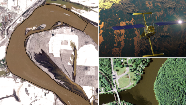
- Sponsor
- Department of Geography and Geographic Information Science
- Speaker
- Tasneem Haq Meem, Geography PhD candidate
- Cost
- This dissertation defense is free and open to the public.
- Contact
- Geography & GIS
- geography@illinois.edu
- Views
- 34
- Originating Calendar
- Geography & Geographic Information Science
Remote Sensing of Fluvial Dynamics in River Confluences and Meander Bends
Accurately characterizing the spatial and temporal dynamics of river systems is important for water resources management. Traditional field methods are labor-intensive, susceptible to noise from flow fluctuations, difficult to repeat under varying hydrological conditions, and particularly challenging in large rivers over large spatial scales. Remote sensing methods provide unprecedented opportunities to observe river dynamics globally at high spatial resolution. The dissertation explores the potential of remote sensing data to investigate fluvial dynamics at river confluences and meandering rivers. The objectives of this dissertation are to: i) evaluate the spatial scales and rates of mixing downstream of river confluences using aerial imagery, ii) investigate the spatial and temporal variations in water surface profiles upstream of river confluences using data from the Surface Water and Ocean Topography (SWOT) satellite, and iii) evaluate changes in lateral water-surface profiles in bends of meandering rivers using SWOT data.
The first study evaluates the average length scales, rates, and variability of lateral mixing downstream at 43 confluences for 150 events based on contrasts in gray‐scale intensity of confluent flows captured by aerial images. Only 45% of the events exhibit complete mixing over the length of the imaged downstream reach. The average dimensionless length scale (sd) of complete mixing is 7.4 times the downstream flow width and varies from sd = 1.1–26.3, but not all flows completely mix. A nonlinear spatial pattern of mixing, consistent with relations derived from shallow flow theory, reveals that mixing rates are substantially higher immediately downstream of confluences with most mixing occurring over sd < 15. The findings confirm that confluences are important locations of accelerated mixing in river networks.
The second study assesses whether the Surface Water and Ocean Topography (SWOT) satellite can detect superelevation in meander bends. Plots of lateral water‐surface slope (LWS)
reveal distinct superelevation in three sets of Mississippi‐River bends. As expected, the magnitude and direction of LWS are strongly correlated with channel curvature. Superelevation can also be detected on comparatively narrow Wabash‐River bends, but levels of noise are more pronounced than for the Mississippi bends. Mean flow velocities derived from LWSs are consistent with velocities estimated from nearby gaging station measurements (±7%–35%). These findings confirm that SWOT data can be used to reliably detect superelevation in large river bends, providing the basis for global assessments of hydrodynamics in large meandering rivers.
The third study evaluates the effects of interaction between incoming flows on water surface profiles (WSPs) upstream of river confluences across varying discharge and momentum ratios. This study provides a theoretical framework combining gradually varied flow principles with one-dimensional hydraulic simulations of an idealized confluence to assess WSPs at the Missouri-Mississippi and Ohio-Mississippi confluences. Simulations from the idealized confluence model indicate that under mainstem dominance, WSE in the tributary increases relative to steady-uniform conditions toward the confluence, producing M1 backwater profiles. Simultaneously, as the dominant flow from the main river accelerates into the confluence, WSE decreases close to the confluence relative to steady-uniform conditions, producing M2 drawdown profiles. Conversely, under tributary dominance, the mainstem exhibits M1 backwater profiles, while the tributary exhibits M2 drawdown profiles. WSPs derived from SWOT at the Missouri-Mississippi and Ohio-Mississippi confluences are consistent with idealized model simulations. Because Mississippi River generally dominates at the Missouri-Mississippi confluence, M1 profiles occur more commonly than M2 profiles along the Missouri River. In contrast, flow dominance alternates between the Ohio and Mississippi rivers at the Ohio-Mississippi confluence, resulting in both M1 and M2 profiles along the Mississippi River. The spatial extents of these
profiles relative to reference conditions (without confluence) can reach up to 5 m vertically at the confluence, and 100 channel widths (tens of kilometers) longitudinally upstream of the confluence. Discharge and momentum ratios exert strong influence on WSE differences at confluences relative to reference profiles, whereas total discharge exerts a secondary influence. Overall, the findings demonstrate that flow interactions between incoming flows can substantially alter the WSE at the confluence and the effects of flow interaction on the WSPs can be spatially extensive.